Category Archives: Maps

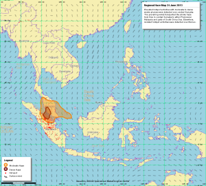
Singapore haze map for 24 June 2013

The BBC World Service has reporting on the dense haze that’s covering Singapore and parts of Malaysia as a result of land-clearing fires in Indonesia. The map below is from the Meteorological Service Singapore. The Indonesian president has apologized for the haze, notes the Straits Times.

Singapore-haze-map-24-June-2013
Singaporeans are advised to wear masks when going outdoors, and to stay indoors if at all possible. SingPost has issued masks for postal workers.


Related articles

In Battle Against Haze, Indonesia Turns to Helicopters and a Plane
Indonesia Says Singapore ‘Behaving Like a Child’ Over Haze
Singapore PM Says Haze from Indonesia Fires May Last for Weeks
The horrible HAZE in Singapore is bad for…
Singapore blanketed with worst ever haze

Black Forest Fire near Colorado Springs, Colorado (with maps updated Thursday 6/13 5:37 p.m MT)

UPDATED Thursday June 13, 6:00 p.m MT with new maps at the top.

The fast-moving Black Forest Fire is burning homes northeast of Colorado Springs, Colorado. High temperatures, high winds, and low humidity are fanning the flames. Two people are known to have died in the fire, and more than 360 homes have been lost. If you are near the fire, please seek out current and official information rather than relying on this weblog. Lots of photos and news are showing up on the #blackforestfire Twitter tag. Residents can call 719-444-8300 for information on the fire, but no exact information is available on individual homes yet. Official info from El Paso County will be more current than this page.

News coverage: Denver Post, “Black Forest Fire near Colorado Springs prompts mandatory evacuations“. Live blog: Colorado Springs Gazette, “LIVE UPDATES

Television: CBS Denver 4, KOAA 5, KKTV 11 (Facebook), KRDO 13.

Fire perimeter map, originally from Weather Underground’s Wundermap. As of Thursday, 19:34 MT.
Black-forest-fire-fire-perimeter-map-1934-mt-thursday-june-13

Fire evacuation map as of 5:37 p.m. MT, June 13, 2013. This map is from the Colorado Springs Gazette, retrieve the latest version if you are in the fire area. Please note the expansion of the fire to the northeast as well as to the southwest.
Black-forest-fire-evacuation-area-1737-thursday-june-13

Fire map as of 9:00 p.m. MT, June 11, 2013. If you are in the affected area, you’ll want to get an updated map. (Map via The Gazette)

Black-forest-fire-evacuation-map

KUSA has a Google Map with additional information including evacuation locations.

Wildfire Today has Maps of Colorado Wildfires with details of three fires: Big Meadow in Rocky Mountain National Park, Black Forest near Colorado Springs, and Royal Gorge at Canon City southwest of Colorado Springs. They also have photos of the fires and other details.

Live coverage: El Paso County Fire and EMS (1200+ listeneres at 9:00 p.m. MT Tues June 11, 2013). Alert message: El Paso County: “Black Forest” fire has burned several hundred acres and destroyed an unknown number of homes/structures. Local, county, state and Federal resources operating. Large and small helo’s and heavy air tankers also operating. (116 minutes ago)

The radar from Weather Underground shows a clear smoke plume.

Black-forest-fire-wunderground-radar-smoke-plume


Related articles

Multiple Homes Burn In Black Forest Fire Northeast Of Colorado Springs
Homes burning in Black Forest Fire in El Paso County
Wild fires in Colorado Springs, Colorado
Red Cross shelters for Colorado wildfires
Fire near Colorado Springs burns homes

I-5 Bridge over the Skagit River collapses in Washington State

This is breaking news, and this blog post will be out of date.

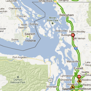
The Interstate 5 bridge over the Skagit River has collapsed near Mount Vernon, Washington. A map shows where the incident happened, about half way between Seattle and the Canadian border.

I-5-Bridge-Collapse-Mount-Vernon-Washington-Skagit-River-Google-Map
As of this writing there are no confirmed details about the cause of the bridge collapse. The Seattle Times says it may have been because an oversized truck hit the bridge with its load. Three people were rescued from the water with minor injuries.

Some sources:

Scanner, via Broadcastify: Skagit County Police and Fire.  4400+ listeners at 8:19 p.m. 5/23/13. This is the initial police response, via Soundcloud and Alertpage.


Skagit Valley-News: Reports: Bridge collapses between Mount Vernon, Burlington

The I-5 Skagit River Bridge is a through-truss bridge that was built in 1955, according to the website Bridgehunter.com. It is the same basic type of design of the Interstate 5 Bridge over the Columbia River in Vancouver, according to the site.

Associated Press: I-5 bridge collapses in NW Wash.; people in water.

Bridgehunter.com: I-5 Skagit River Bridge. Includes maps and photos of bridge.

National Bridge Inventory Database details follow, from NationalBridges.com. The structural evaluation is "Somewhat better than minimum adequacy to tolerate being left in place as is".

State: WA
Place Name: Mount Vernon
County: Skagit
NBI Structure Number: 0004794A0000000
Route Sign Prefix: Interstate
Route Number: 5
Facility Carried: I-5
Feature Intersected: SKAGIT RIVER
Location: 0.7 N JCT SR 538
Year Built: 1955
Status: Functionally Obsolete
RecordType: Roadway is carried ON the structure
Level of Service: Mainline roadway
Owner: State Highway Agency
Highway Agency District: 01
Maintenance Responsibility: State Highway Agency
Functional Class: Principal Arterial – Interstate, Urban
Service On Bridge: Highway
Service Under Bridge: Highway-waterway
Latitude: 48 26 35.80 N
Longitude: 122 20 27.90 W
Material Design: Steel
Design Construction: Truss – Thru
Approach Material Design: Concrete continuous
Approach Design Construction: Tee Beam
Structure Length (m): 338.9
Navigation Vertical Clearance (m): 2.4
Approach Roadway Width (m): 21.9
Lanes on Structure: 4
Lanes under Structure: 4
Average Daily Traffic: 70925
Year of Average Daily Traffic: 2010
Design Load: MS 18
Scour: Bridge foundations determined to be stable for assessed or calculated scour condition.
Bridge Railings: Meet currently acceptable standards.
Historical Significance: Bridge is not eligible for the National Register of Historic Places.
# of Spans in Main Structure: 4
# of Spans in Approach Structures: 8
StructureFlared: No flare
Transitions: Does not meet currently acceptable standards.
Approach Guardrail: Meets currently acceptable standards.
Approach Guardrail Ends: Not Applicable
Navigation Control: Navigation control on waterawy (bridge permit required).
Navigation Horizontal Clearance (m): 33.5
Structure Open?: Open, no restrictions
Deck: Satisfactory Condition
Superstructure: Fair Condition
Substructure: Satisfactory Condition
Structural Evaluation: Somewhat better than minimum adequacy to tolerate being left in place as is
Sufficiency Rating (%): 57.4

 News coverage – this may change as time progresses:

KING 5 live coverage.

I-5-Bridge-Collapse-Skagit-River-KING-5-Screencap
KIRO 7 live coverage.

I-5-Bridge-Collapse-Skagit-River-KIRO-7-Screencap

2013 Moore Oklahoma tornado path map

This map from the National Weather Service in Norman, Oklahoma (via Atlantic Cities) shows the destructive path of the Moore, Oklahoma tornado of 20 May 2013. This is a preliminary map that also shows the track of a 3 May 1999 tornado that followed a very similar path.

2013-moore-oklahoma-tornado-path-map

There's too much graphic, devastating imagery from the scene which I won't include here. Dr Jeff Masters has an excellent overview of the meteorology of the event, including accounts of debris being thrown 100 miles in the air to land on Tulsa, Oklahoma.

UPDATE: The National Environmental Visualization Laboratory has this image of radar rotational velocity across the storms of that day, showing tornadic activity in darker colors. (Credit: NOAA)

1352v1_20130521-Moore_Tornado-Rotation
UPDATE: The Google Crisis Map for 2013 Oklahoma tornadoes includes a track of the tornado plus shelter information and links to other local resources. I've included a snapshot from Tuesday evening, May 21, 2013.

Google-Moore-Oklahoma-Tornado-path-track-crisis-map

UPDATE: A second National Weather Service map shows the detail of where the tornado was at its maximum intensity. (Credit: National Weather Service, Norman OK, via Facebook)

Nws-moore-tornado-path-outline-ef-5
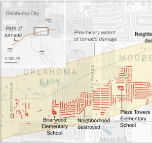
UPDATE: The New York Times has a detailed tornado track map for the Moore, Oklahoma tornado. I've excerpted a piece of it here by way of illustration. Their article also has before and after aerial photos of the damage.

New-York-Times-Moore-Oklahoma-Tornado-Track-Map-excerpt


Wet West Michigan: maps of flooding, April 2013

This map from MLive shows roads closed due to flooding in Western Michigan. (Turn around, don't drown). Click through for the interactive version.

Screen shot 2013-04-21 at 3.23.18 PM
A similar map from NOAA shows flood gauge readings across the area.

Screen shot 2013-04-21 at 3.26.59 PM
The purple gauge in this above map is Grand Rapids at Comstock Park, which is showing flooding at almost 6 feet above flood stage.

Screen shot 2013-04-21 at 3.29.56 PM
The historical big flood in Grand Rapids is from 1904; this collection rephotographs scenes from that flood in 2004.

Walking on water

I was out for a walk along the Huron River, and Runtastic mapped it as though I was actually in the middle of the river.

Screen shot 2013-04-21 at 2.56.46 PM
There's actually a path in the "middle" of the river, a berm that separates the Argo Cascades city park from the Huron River per se. Microsoft and Nokia don't appear to know about that path, just illustrating some of the perils of computing walking directions in an urban environment.

Algerian oil and gas pipeline and field map (from mem-algeria.org)

The map below is a reduced size of the original, which is an oil and gas pipeline and field map of Algeria. It's hosted on the site mem-algeria.org and doesn't have any other credits on the map. (Not for use in navigation.)

MEM stands for Ministère de l’Energie et des Mines; this is an official map from that ministry of the Algerian government.

Algeria_oil_gas_hydrocarbon_map_mem_algeria
The incident of late – see Bloomberg News story of 18 January 2013 – focus on the complex at the Amenas Gas Field; a detail of this map is below, showing Amenas (labelled here as "In Amenas") near the border with Libya.

Screen shot 2013-01-18 at 4.37.22 PM
More details:

BP: "BP in Algeria" with maps of In Amenas, though not at this detail; full sized map (PDF)


Related articles
Army operation at Algeria siege
Hostages 'escape Algeria captors'
Militants: 35 hostages die in Algerian raid
Algeria hostage crisis 'ongoing', says Foreign Office – live updates – The Guardian
Dozens of hostages 'killed' in Algeria
Desert Massacre Threatens Africa's Largest Gas Industry

Northern Lights for November 12, 2012

Tonight’s northern lights are visible in Yellowknife, Canada. Here’s a snapshot from the AuroraMAX HD camera. (Tonight is Monday, November 12, 2012.)

Recent_480p
The forecast for tonight from the University of Alaska suggests that the aurora may be visible as far south as Lansing, Michigan. From my Pinterest maps board:

Some evidence of sightings:

The Twitter account @Aurora_Alerts is active when the Northern Lights are active, and it gives very short term forecasts of activity. The higher the Kp number, the brighter the aurora.

The Twitter account @AuroraMAX belongs to the night sky camera that took the snapshot above. It is run by the Canadian Space Agency, and their (English language) homepage has more information about their setup.