Google search: black river falls michigan fire map
Twitter search: black river falls
As of 21 May 2009 there is a fire burning near Ishpeming, MI called the Black River Falls fire. It’s not in a densely populated area, but several dozen structures have burned, and there’s a lot of crews that have been brought in to help fight the fire.
When the Sleeper Lake Fire burned near Newberry, MI there was a lot of news that came out piecemeal from media, residents, and bloggers in the area. I’m hoping to collect some of that same level of detail here. It’s always a big concern when forests burn, especially when they burn uncontrolled in land that doesn’t have a lot of roads in it.
Here’s some details I’ve been able to figure out so far.
The Yooper Daily blog from Shawn and Brian Malone, commercial photographers, has a post titled simply Wildfires Break Out In UP. They have an approximate map of the Black River Falls fire which shows it deep in the woods of Ely Township.
A lot of my searches go to another fire called the Black River Falls fire, but in Jackson County Wisconsin; this historical marker describes a 1977 fire, the traces of which are almost gone by now with timber regrowth.
The Remote Sensing Applications Center of the USDA Forest Service has a series of maps, including this Northern Midwest fire map (Northern Iowa, Minnesota, Michigan, Wisconsin). The current one I’m looking at shows the Pinery Fire near L’Anse, MI, but nothing from the Black River Falls fire. The scale on this is fairly large, so it doesn’t pin down the precise acreage, just the nearest town.

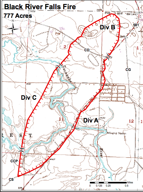
 For a more detailed map you turn to the Michigan DNR, which is preparing maps for active fire fighting. This sample shows the extent of the fire as of last update, though it doesn’t have a date on the map, the file date is 20090521 (may 21, 2009).
I’m stopping here because this is what I started looking for, and you’ll want to stay tuned to whatever other news sources you have if you’re close to the fire.
On twitter I notice updates from @MDNR @wluctv6 @miningjournal and @nortman and expect to collect more. It’s worth noting that the Mining Journal has extremely terse 60 character headlines on Twitter which means that typical keyword style searches don’t find them very well, though once you do find their news stream the writing and reporting is first rate, and they have interviews of people at the Red Cross shelter at Westwood High School which is quite evidently information central for families affected by the blaze.
ISHPEMING – Sandwiches, coffee, donuts, cots to sleep on – the American Red Cross shelter, set up at the Westwood High School gym, was ready to fill the needs of residents evacuated due to the Black River Falls fire off Marquette County Road 581.
The thing the evacuees were wanting most, however, was news about the fire.
Of the 300 people who passed through the shelter Wednesday, the vast majority wanted news about their homes and neighbors, said Red Cross Executive Director Kayla West.
“They wanted information more than anything,” she said.
The coverage from WLUC TV6 has video
http://www.uppermichiganssource.com/news/news_story.aspx?id=302523
but no maps that I could see.